Biotrop-X:
Innovative methods to calculate biomass of tropical forests from TanDEM-X data
Biotrop-X is a colaborative project between the Helmholtz Centre for Environmental Research (UFZ) and the German Aerospace Center (DLR). Its target is the development of new methods for local calculation of biomass stocks in different tropical forest areas using remote sensing systems such as TanDEM-X. The outcomes should contribute to continuous coverage mapping of above ground carbon stocks in vegetation and their dynamics. Concrete tasks are, first of all, finding relations between parameters measurable via remote sensing, e.g. the height profile of tree crowns, and intrinsic properties, like the biomass of the forest. Furthermore, it needs to be investigated whether these relationships are valid and applicable for different geographical regions and forest ecosystems, and what the accuracy of carbon balances inferred from repeated radar measurements would be.
Forest growth simulations serve as an important tool to answer these questions. With forest models like FORMIND large datasets of virtual forest inventories can be generated, which thereafter can be systematically screened for the above mentioned relationships. Found relations are validated based on measurement data from real forest inventory plots at different research sites in combination with the corresponding TanDEM-X measurements from these sites.
The project is divided into the following stages: At first, information about forest height and structure are generated from TanDEM-X data. Then, different scenarios are simulated with FORMIND and resulting data will be searched for relations between the different forest characteristics. In the next step, the knowledge gained from the simulations will be transferred to the field data to make predictions about the biomass in the test areas based on radar data. Following that, it will be investigated, whether time series of radar scans allow conclusions on biomass dynamics. In the final stage, all predictions will be validated based on the inventory data and the models will be tested for their general applicability.
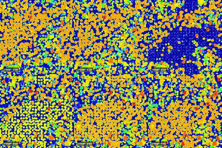
Canopy height model (CHM) of 25 ha of the Barro Colorado Island forest in Panama grown in FORMIND. Fires cause disturbance followed by natural succession. CHMs are derived from Lidar simulations. Radar will have lower spatial resolution than Lidar.
The anticipated result will be a model which allows deriving the biomass of an arbitrary tropical forest, independent of its geographic location or forest type, from TanDEM-X data. Subsequently, the model can be utilized for large scale mapping.
Test site:
BCI, Panama
Publications:
Linking lidar and forest modeling to assess biomass estimation across scales and disturbance states
Knapp, Fischer & Huth (2018) Remote Sensing of Environment
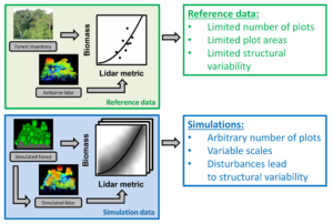
Reference data from field inventories and an airborne lidar campaign were used to parameterize and calibrate FORMIND and a lidar model. With the models, large quantities of simulated inventory and simulated lidar data were generated, allowing for a systematic analysis of lidar-to-biomass relationships under different disturbance regimes and for various spatial scales.
Light detection and ranging (lidar) is currently the state-of-the-art remote sensing technology for measuring the 3D structures of forests. Studies have shown that various lidar-derived metrics can be used to predict forest attributes, such as aboveground biomass. However, finding out which metric works best at which scale and under which conditions requires extensive field inventories as ground-truth data. The goal of our study was to overcome the limitations of inventory data by complementing field-derived data with virtual forest stands from a dynamic forest model.
The simulated stands were used to compare 29 different lidar metrics for their utility as predictors of tropical forest biomass at different spatial scales. We used the process-based forest model FORMIND, developed a lidar simulation model, based on the Beer-Lambert law of light extinction, and applied it to a tropical forest in Panama. Simulation scenarios comprised undisturbed primary forests and stands exposed to logging and fire disturbance regimes, resulting in mosaics of different successional stages, totaling 3.7 million trees on 4,200 ha. The simulated forest was sampled with the lidar model.
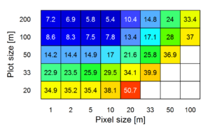
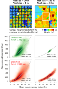
Relative errors of biomass estimations from top-of-canopy height for a disturbed forest at different plot sizes and pixel sizes. The values represent nRMSE in percent of the mean biomass.
Several lidar metrics, in particular height metrics, showed good correlations with forest biomass, even for disturbed forest. Estimation errors (nRMSE) increased with decreasing spatial scale from < 10% (200-m scale) to > 30% (20-m scale) for the best metrics. At the often used 1-ha scale, the top-of-canopy height obtained from canopy height models with fine to relatively coarse pixel resolutions (1 to 10 m) yielded the most accurate biomass predictions, with nRMSE < 6% for undisturbed and nRMSE < 9% for disturbed forests. This study represents the first time dynamic modeling of a tropical forest has been combined with lidar remote sensing to systematically investigate lidar-to-biomass relationships for varying lidar metrics, scales and disturbance states. In the future, this approach can be used to explore the potential of remote sensing of other forest attributes, e.g., carbon dynamics, and other remote sensing systems, e.g., spaceborne lidar and radar.
Model-assisted estimation of tropical forest biomass change: a comparison of approaches
Knapp et al. (2018) MDPI Remote Sensing
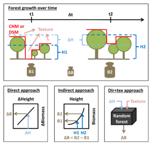
Inputs and principles of the three different approaches to derive biomass change (ΔB) over time from observed canopy heights (H) or height change (ΔH) and canopy texture, respectively.
Monitoring of changes in forest biomass requires accurate transfer functions between remote sensing derived changes in canopy height (ΔH) and the actual changes in aboveground biomass (ΔAGB). Different approaches can be used to accomplish this task: Direct approaches link ΔH directly to ΔAGB. Indirect approaches are based on deriving AGB stock estimates for two points in time and calculating the difference. In some studies direct approaches led to more accurate estimations, while in others indirect approaches led to more accurate estimations. It is unknown how each approach performs under different conditions and over the full range of possible changes. Here, we used a forest model (FORMIND) to generate a large dataset (> 28,000 ha) of natural and disturbed forest stands over time. Remote sensing of forest height was simulated on these stands to derive canopy height models for each time step. Three approaches for estimating ΔAGB were compared: (1) the direct approach, (2) the indirect approach and (3) an enhanced direct approach (dir+tex), using ΔH in combination with canopy texture.

Simulated data showing the relationship between the change in mean top-of-canopy height at 10-m pixel resolution (ΔTCH10) and the change in aboveground biomass (ΔAGB) for a 5-yr time interval between first and second measurement. Each point represents a 1-ha forest stand.
Total prediction accuracies of the three approaches measured as root mean squared errors were RMSEdirect = 18.7 t ha−1, RMSEindirect = 12.6 t ha−1 and RMSEdir+tex = 12.4 t ha−1. Further analyses revealed height-dependent biases in the ΔAGB estimates of the direct approach, which did not occur with the other approaches. Finally, the three approaches were applied on radar-derived (TanDEM-X) canopy height changes on Barro Colorado Island (Panama). The study demonstrates the potential of forest modeling for improving the interpretation of changes observed in remote sensing data and for comparing different methodologies.
Contact: Nikolai Knapp, Rico Fischer


